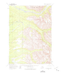
1954 Map of Lime Hills B-4
USGS Topo · Published 1975About this map
Revelation Mountains dominate the northern landscape of this interior Alaskan quadrangle, surveyed in the mid-1950s using photogrammetric methods from aerial photography. The terrain is defined by a dense network of high-elevation glacial drainage, most notably the Swift River which cuts across the northern reaches. This 1:63,360 scale map reveals a completely undeveloped wilderness at the time of the survey, with land lines representing unsurveyed locations predetermined by the Bureau of Land Management. Smaller waterways like Underhill Creek, Little Underhill Creek, and Rock Creek carve through the southern valleys, providing a detailed look at the hydrological patterns of the Kuskokwim River watershed before any significant human footprint was established in this remote section of the Bethel area.
Find a feature on this map
5 named features on this map. Tap any name to fly to it.
Don’t see what you’re looking for? This feature index may not catch every label — zoom into the map to look around manually.
Map Details
Editions of this 1954 Lime Hills B-4 Map
2 editions found
Other maps of this area

1951 · Lime Hills
USGS Topo · 1:250,000
1954 · Lime Hills C-5
USGS Topo · 1:63,360

1954 · Lime Hills A-5
USGS Topo · 1:63,360

1954 · Lime Hills A-3
USGS Topo · 1:63,360

1954 · Lime Hills B-4
USGS Topo · 1:63,360

1954 · Lime Hills A-4
USGS Topo · 1:63,360

1954 · Lime Hills B-5
USGS Topo · 1:63,360

1954 · Lime Hills B-3
USGS Topo · 1:63,360

1958 · Lime Hills C-3
USGS Topo · 1:63,360

1958 · Lime Hills C-4
USGS Topo · 1:63,360