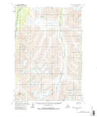
1958 Map of Lime Hills C-1
USGS Topo · Published 1986About this map
South Fork Kuskokwim River flows through this interior wilderness, providing a primary drainage route for the high mountain valleys during the late 1950s. The landscape is defined by the steep relief of the western Alaska Range, where the Styx River carves deep north-south passages through the terrain. Mapping was conducted via photogrammetric methods from aerial photographs taken between 1953 and 1957 by the U. S. Geological Survey, revealing a region with no established roads or trails at the time of the 1958 field annotation. Small bodies of water like Jimmy Lake and the drainage of Crystal Creek suggest a landscape largely shaped by glacial activity and seasonal melt. This survey captures a moment before modern infrastructure, documenting the raw hydrography and topography of the Bethel area.
Find a feature on this map
9 named features on this map. Tap any name to fly to it.
Don’t see what you’re looking for? This feature index may not catch every label — zoom into the map to look around manually.
Map Details
Editions of this 1958 Lime Hills C-1 Map
3 editions found
Other maps of this area

1949 · Tyonek
USGS Topo · 1:250,000

1951 · Tyonek
USGS Topo · 1:250,000

1951 · Lime Hills
USGS Topo · 1:250,000

1958 · Tyonek B-8
USGS Topo · 1:63,360

1958 · Tyonek C-8
USGS Topo · 1:63,360

1958 · Tyonek D-8
USGS Topo · 1:63,360

1958 · Tyonek
USGS Topo · 1:250,000

1958 · Lime Hills B-1
USGS Topo · 1:63,360
1958 · Lime Hills D-1
USGS Topo · 1:63,360

1958 · Lime Hills C-1
USGS Topo · 1:63,360