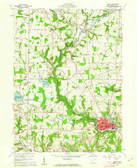
1960 Map of Lisbon
USGS Topo · Published 1962About this map
Lisbon serves as the focal point of this Eastern Ohio landscape, where the Middle Fork Little Beaver Creek meanders through a mix of industrial activity and established rural settlements. The infrastructure of the early 1960s is clearly defined, showing the convergence of the Pennsylvania and Erie Lackawanna railroads near Leetonia. This era reveals a transition in land use, where traditional agriculture on Gromley Hill and small crossroads like McCracken Corners coexist with extensive Strip Mine operations and numerous Gas Wells to the east.
Find a feature on this map
82 named features on this map. Tap any name to fly to it.
Don’t see what you’re looking for? This feature index may not catch every label — zoom into the map to look around manually.
Map Details
Editions of this 1960 Lisbon Map
4 editions found
Other maps of this area

1904 · Wellsville
USGS Topo · 1:62,500

1905 · Salineville
USGS Topo · 1:62,500

1907 · Columbiana
USGS Topo · 1:62,500

1909 · Lisbon
USGS Topo · 1:62,500

1909 · Columbiana
USGS Topo · 1:62,500

1937 · Wellsville
USGS Topo · 1:62,500

1944 · Wellsville
USGS Topo · 1:62,500

1951 · Canton
USGS Topo · 1:250,000

1951 · Columbiana
USGS Topo · 1:24,000

1952 · Damascus
USGS Topo · 1:24,000