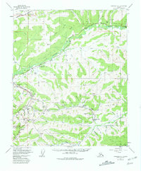
1952 Map of Livengood A-1
USGS Topo · Published 1981About this map
The gold mining legacy of the Yukon-Tanana Uplands is etched across this landscape, where the Davidson Ditch snakes through the hills to provide water for hydraulic operations. This survey documents the mid-century state of historic mining districts, featuring now-silent settlements like Cleary and Golden City. The rugged infrastructure of the era is evident in the numerous Siphon locations and extensive Tailings along Chatham Creek. High-elevation landmarks such as Pedro Dome and Cleary Summit anchor the topography, while the Steese Highway provides the primary artery through this interior terrain. Notable industrial sites include the McCarty Mine and the Cleary Hill Mine, illustrating the intense focus on mineral extraction that defined the development of the Fairbanks North Star Borough. Farther north, the map touches the southern reaches of the Yukon Flats National Monument, where the terrain transitions into the vast Yukon Flats.
Find a feature on this map
84 named features on this map. Tap any name to fly to it.
Don’t see what you’re looking for? This feature index may not catch every label — zoom into the map to look around manually.
Map Details
Editions of this 1952 Livengood A-1 Map
3 editions found

Other maps of this area

1945 · Livengood
USGS Topo · 1:250,000

1949 · Fairbanks D-1
USGS Topo · 1:62,500

1949 · Fairbanks D-2
USGS Topo · 1:62,500

1950 · Fairbanks
USGS Topo · 1:250,000

1950 · Big Delta
USGS Topo · 1:250,000

1950 · Big Delta D-6
USGS Topo · 1:63,360

1951 · Big Delta
USGS Topo · 1:250,000

1951 · Fairbanks
USGS Topo · 1:250,000

1951 · Livengood
USGS Topo · 1:250,000

1951 · Circle
USGS Topo · 1:250,000