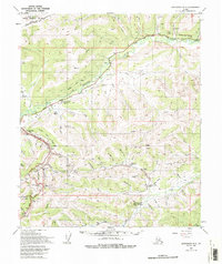
1952 Map of Livengood A-1
USGS Topo · Published 1994About this map
Mining operations and historical campsites define this portion of the Fairbanks North Star Borough during the early 1950s. The landscape is marked by the winding path of the Davidson Ditch (Aband), an ambitious hydraulic mining water system that once served the gold fields. Several former communities are recorded as sites, including Cleary, Golden City, and Meehan, illustrating the shifting nature of settlement in the Alaskan interior as mineral resources were sought and exhausted.
Find a feature on this map
71 named features on this map. Tap any name to fly to it.
Don’t see what you’re looking for? This feature index may not catch every label — zoom into the map to look around manually.
Map Details
Editions of this 1952 Livengood A-1 Map
3 editions found

Other maps of this area

1945 · Livengood
USGS Topo · 1:250,000

1949 · Fairbanks D-1
USGS Topo · 1:62,500

1949 · Fairbanks D-2
USGS Topo · 1:62,500

1950 · Fairbanks
USGS Topo · 1:250,000

1950 · Big Delta
USGS Topo · 1:250,000

1950 · Big Delta D-6
USGS Topo · 1:63,360

1951 · Big Delta
USGS Topo · 1:250,000

1951 · Fairbanks
USGS Topo · 1:250,000

1951 · Livengood
USGS Topo · 1:250,000

1951 · Circle
USGS Topo · 1:250,000