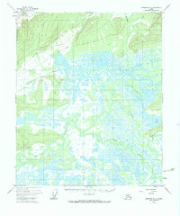
1951 Map of Livengood A-5
USGS Topo · Published 1983About this map
The Tolovana River and Chatanika River converge in a sprawling expanse of wetlands and floodplains mapped in the early 1950s. This interior Alaskan landscape is defined by the shifting paths of the Tatalina River and numerous tributaries such as Uncle Sam Creek. Settlement is sparse, anchored by the community at Minto (New), which sits adjacent to a designated Landing Strip and a network of Tractor Trails. The presence of isolated Cabins and traditional routes through the low-lying terrain north of Cod Lake reflects the area's continued reliance on river access and aviation during this era. Surveyed by the U.S. Geological Survey with photogrammetric methods, the map details a complex watery environment where seasonal fluctuations dictate movement and land use across the unsurveyed locations of the Interior.
Find a feature on this map
12 named features on this map. Tap any name to fly to it.
Don’t see what you’re looking for? This feature index may not catch every label — zoom into the map to look around manually.
Map Details
Editions of this 1951 Livengood A-5 Map
4 editions found
Other maps of this area

1945 · Livengood
USGS Topo · 1:250,000

1949 · Fairbanks D-4
USGS Topo · 1:63,360

1950 · Fairbanks
USGS Topo · 1:250,000

1950 · Fairbanks D-5
USGS Topo · 1:63,360

1951 · Fairbanks
USGS Topo · 1:250,000

1951 · Livengood
USGS Topo · 1:250,000

1951 · Livengood A-5
USGS Topo · 1:63,360

1951 · Livengood A-4
USGS Topo · 1:63,360

1952 · Fairbanks D-4
USGS Topo · 1:63,360

1952 · Livengood A-6
USGS Topo · 1:63,360