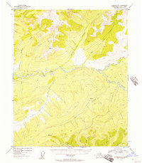
1954 Map of Livengood B-1
USGS Topo · Published 1958About this map
Beaver Creek and Nome Creek dominate this 1950s interior Alaskan landscape, where the drainage patterns of the White Mountains reveal a history of resource exploration. High-elevation survey points like VABM 3510 O'Brien and VABM 2578 Ophir overlook a network of tributary streams that include O'Brien Creek, Ophir Creek, and Mc Kay Creek. The presence of isolated Cabins and a lone Mine near the eastern bend of Nome Creek points to the small-scale prospecting and seasonal residency characteristic of the Fourth Judicial Division during this era. A single Trail serves as the primary overland artery, weaving through the valleys of the Fossil Cr region, connecting these remote outposts to the broader territorial interior before the development of modern road networks in the Yukon-Koyukuk region.
Find a feature on this map
17 named features on this map. Tap any name to fly to it.
Don’t see what you’re looking for? This feature index may not catch every label — zoom into the map to look around manually.
Map Details
Editions of this 1954 Livengood B-1 Map
4 editions found

Other maps of this area

1945 · Livengood
USGS Topo · 1:250,000

1951 · Livengood
USGS Topo · 1:250,000

1951 · Circle
USGS Topo · 1:250,000

1951 · Livengood C-2
USGS Topo · 1:63,360

1951 · Livengood C-1
USGS Topo · 1:63,360

1951 · Circle C-6
USGS Topo · 1:63,360

1951 · Livengood B-2
USGS Topo · 1:63,360

1952 · Livengood A-2
USGS Topo · 1:63,360

1952 · Livengood A-1
USGS Topo · 1:63,360

1954 · Livengood C-2
USGS Topo · 1:63,360