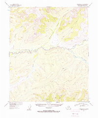
1954 Map of Livengood B-1
USGS Topo · Published 1958About this map
Beaver Creek carves a winding path through the center of this interior Alaska landscape, defining a remote territory where early 1950s surveying recorded the footprints of resource extraction and seasonal habitation. Evidence of mid-century activity is concentrated along the southern tributaries, where a marked Mine and scattered Cabins suggest a persistent interest in the mineral potential of the drainage basins.
Find a feature on this map
18 named features on this map. Tap any name to fly to it.
Don’t see what you’re looking for? This feature index may not catch every label — zoom into the map to look around manually.
Map Details
Editions of this 1954 Livengood B-1 Map
4 editions found

Other maps of this area

1945 · Livengood
USGS Topo · 1:250,000

1951 · Livengood
USGS Topo · 1:250,000

1951 · Circle
USGS Topo · 1:250,000

1951 · Livengood C-2
USGS Topo · 1:63,360

1951 · Livengood C-1
USGS Topo · 1:63,360

1951 · Circle C-6
USGS Topo · 1:63,360

1951 · Livengood B-2
USGS Topo · 1:63,360

1952 · Livengood A-2
USGS Topo · 1:63,360

1952 · Livengood A-1
USGS Topo · 1:63,360

1954 · Livengood C-2
USGS Topo · 1:63,360