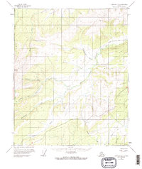
1952 Map of Livengood B-5
USGS Topo · Published 1963About this map
Sawtooth Mountain dominates the western landscape of this interior Alaskan wilderness, as mapped during the early 1950s. The region is defined by a complex drainage network where the Mud Fork of Hess Creek and the West Fork Tolovana River carve through the high terrain. Human presence is sparse and temporary, evidenced only by an isolated Landing Strip and a Cabin situated near the eastern edge of the quadrangle. This era of exploration relied heavily on overland routes, shown here by a series of Tractor Trails and pack trails that cut across the valleys of Starvation Creek and Moose Creek. The mapping reflects a landscape in transition, where land lines represent unsurveyed locations predetermined by the Bureau of Land Management, capturing the raw geography of the Yukon-Koyukuk region before significant modern development.
Find a feature on this map
17 named features on this map. Tap any name to fly to it.
Don’t see what you’re looking for? This feature index may not catch every label — zoom into the map to look around manually.
Map Details
Editions of this 1952 Livengood B-5 Map
3 editions found
Other maps of this area

1945 · Livengood
USGS Topo · 1:250,000

1951 · Livengood
USGS Topo · 1:250,000

1951 · Livengood A-5
USGS Topo · 1:63,360

1951 · Livengood A-4
USGS Topo · 1:63,360

1952 · Livengood A-6
USGS Topo · 1:63,360

1952 · Livengood C-5
USGS Topo · 1:63,360

1952 · Livengood B-5
USGS Topo · 1:63,360

1952 · Livengood C-4
USGS Topo · 1:63,360

1953 · Livengood B-4
USGS Topo · 1:63,360

1953 · Livengood A-4
USGS Topo · 1:63,360