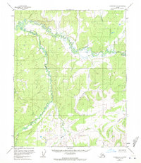
1952 Map of Livengood C-5
USGS Topo · Published 1971About this map
Hess Creek meanders through this portion of the Yukon-Koyukuk region, defining a landscape of complex drainage patterns and unsurveyed land lines. The water network is the primary identifier of the terrain, with Troublesome Creek and its many winding tributaries cutting through the interior of the quadrangle. These drainage basins were mapped from aerial photography in the early 1950s, representing a time when the region remained largely untouched by permanent road infrastructure or settlements.
Find a feature on this map
7 named features on this map. Tap any name to fly to it.
Don’t see what you’re looking for? This feature index may not catch every label — zoom into the map to look around manually.
Map Details
Editions of this 1952 Livengood C-5 Map
4 editions found
Other maps of this area

1945 · Livengood
USGS Topo · 1:250,000

1951 · Livengood
USGS Topo · 1:250,000

1952 · Livengood C-5
USGS Topo · 1:63,360

1952 · Livengood B-5
USGS Topo · 1:63,360

1952 · Livengood D-5
USGS Topo · 1:63,360

1952 · Livengood C-4
USGS Topo · 1:63,360

1953 · Livengood B-4
USGS Topo · 1:63,360

1953 · Livengood D-4
USGS Topo · 1:63,360

1954 · Livengood D-4
USGS Topo · 1:63,360

1954 · Livengood C-4
USGS Topo · 1:63,360