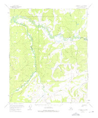
1952 Map of Livengood C-5
USGS Topo · Published 1975About this map
Hess Creek and its many meandering tributaries define this interior Alaskan landscape as it appeared during the 1950s. The terrain is dominated by the complex drainage systems of Troublesome Creek and Richardson Creek, which carve through the unsurveyed wilderness of the Yukon-Koyukuk region. This specific era shows the early infrastructure related to the Haul Road TAPS, a critical precursor to the development of the trans-Alaska pipeline corridor. Small-scale industrial and transport features are visible, including a remote Landing Strip and a Gravel Pit, providing evidence of mid-century exploration and resource management. The map also records several family-named or descriptive waterways such as Mastodon Creek, Fish Creek, and the Mud Fork, which serve as primary landmarks in this road-sparse environment.
Find a feature on this map
11 named features on this map. Tap any name to fly to it.
Don’t see what you’re looking for? This feature index may not catch every label — zoom into the map to look around manually.
Map Details
Editions of this 1952 Livengood C-5 Map
4 editions found
Other maps of this area

1945 · Livengood
USGS Topo · 1:250,000

1951 · Livengood
USGS Topo · 1:250,000

1952 · Livengood C-5
USGS Topo · 1:63,360

1952 · Livengood B-5
USGS Topo · 1:63,360

1952 · Livengood D-5
USGS Topo · 1:63,360

1952 · Livengood C-4
USGS Topo · 1:63,360

1953 · Livengood B-4
USGS Topo · 1:63,360

1953 · Livengood D-4
USGS Topo · 1:63,360

1954 · Livengood D-4
USGS Topo · 1:63,360

1954 · Livengood C-4
USGS Topo · 1:63,360