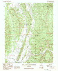
1983 Map of Llaves
USGS Topo · Published 1983About this map
The high-desert terrain of northern New Mexico is defined here by the rugged boundaries of the Santa Fe National Forest and the winding course of the Rio Gallina. Small settlements like Llaves and Cañoncito anchor the southwestern corner of the quadrangle, where a local Landing Strip suggests the area's isolation and reliance on aerial access in the early 1980s. The landscape is a network of water-carved features, from the dramatic elevations of Gallina Peak and Dead Man Peak to the numerous seasonal drainages such as Arroyo Chupadero and Arroyo Archuleta. For those tracing the historical geography of Rio Arriba County, the map identifies specific water sources vital to this arid environment, including Alkali Spr, Mud Spring, and Cedar Spring, which likely served as critical landmarks for local ranchers and travelers long before this provisional survey was finalized.
Find a feature on this map
22 named features on this map. Tap any name to fly to it.
Don’t see what you’re looking for? This feature index may not catch every label — zoom into the map to look around manually.
Map Details
Editions of this 1983 Llaves Map
2 editions found
Other maps of this area

1909 · Gallina
USGS Topo · 1:125,000

1953 · Laguna Peak
USGS Topo · 1:24,000

1953 · Navajo Peak
USGS Topo · 1:24,000

1954 · Aztec
USGS Topo · 1:250,000

1955 · Llaves
USGS Topo · 1:62,500

1955 · Tierra Amarilla
USGS Topo · 1:62,500

1955 · Boulder Lake
USGS Topo · 1:62,500

1958 · Aztec
USGS Topo · 1:250,000

1962 · Aztec
USGS Topo · 1:250,000

1965 · Aztec
USGS Topo · 1:250,000