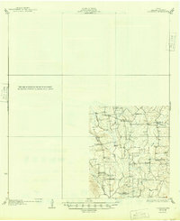
1930 Map of Lockhart
USGS Topo · Published 1949About this map
Plum Creek and its numerous tributaries, including Daniels Creek and Copperas Creek, define the rural landscape of this 1925 survey area. The topography reveals a dense network of early 20th-century community centers, marked by numerous rural schools and churches that served as the anchors for local life. Settlements like McMahan and Tilmon appear as small hubs within a geography of family farms and seasonal drainages.
Find a feature on this map
28 named features on this map. Tap any name to fly to it.
Don’t see what you’re looking for? This feature index may not catch every label — zoom into the map to look around manually.
Map Details
Editions of this 1930 Lockhart Map
2 editions found

Other maps of this area

1885 · Bastrop
USGS Topo · 1:125,000

1893 · Bastrop
USGS Topo · 1:125,000

1896 · Austin
USGS Topo · 1:125,000

1897 · Austin
USGS Topo · 1:125,000

1901 · Flatonia
USGS Topo · 1:125,000

1904 · Bastrop
USGS Topo · 1:125,000

1910 · Austin
USGS Topo · 1:125,000

1911 · San Marcos
USGS Topo · 1:125,000

1919 · San Marcos
USGS Topo · 1:125,000

1925 · San Marcos 1-d
USGS Topo · 1:48,000