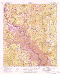
1956 Map of Logansport
USGS Topo · Published 1969About this map
The Sabine River forms a complex boundary between Louisiana and Texas, winding through a landscape defined by expansive bottomlands and the Sabine National Forest. In the mid-1950s, this border region centered on Logansport was a mix of rural industry and established community life. The Spider Gas Field in the northeast indicates the region's energy resources, while the Texas and Pacific RR provides a critical transportation spine through the town of Stanley. A 1969 revision reveals significant changes to the river's character as the Toledo Bend Reservoir project began to impact the drainage, particularly around features like Wildcat Bend and Old River Lake. For those tracing local history, the map preserves the locations of numerous rural institutions, from the Ashton Sch (Abandoned) and Lula Sch to country churches such as Antioch Ch and Beulah Ch.
Find a feature on this map
83 named features on this map. Tap any name to fly to it.
Don’t see what you’re looking for? This feature index may not catch every label — zoom into the map to look around manually.
Map Details
Editions of this 1956 Logansport Map
4 editions found

Other maps of this area

1941 · Zwolle
USGS Topo · 1:62,500

1941 · Pelican
USGS Topo · 1:62,500

1943 · Pleasant Hill
USGS Topo · 1:62,500

1944 · Logansport
USGS Topo · 1:62,500

1944 · Patroon
USGS Topo · 1:62,500

1944 · Zwolle
USGS Topo · 1:62,500

1944 · Pleasant Hill
USGS Topo · 1:62,500

1945 · Grand Cane
USGS Topo · 1:62,500

1945 · Socagee Bayou
USGS Topo · 1:62,500

1945 · Mansfield
USGS Topo · 1:62,500