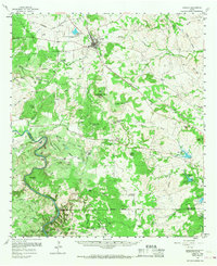
1959 Map of Lometa
USGS Topo · Published 1968About this map
The Colorado River carves a winding path along the western edge of this Lampasas County landscape, creating dramatic bends such as McAnelly Bend and the landmark Old Letdown Point. Situated at a key junction of the At & Sf RR, the town of Lometa serves as the regional hub, surrounded by a topography defined by limestone quarries and deep canyons like Pole Bar Canyon. Notable for its natural springs, the area features the cascades of Gorman Falls and the secluded Gorman Spring. Genealogy researchers will find several historic burial sites, including Center Cem and Nix Cem, along with the Senterfitt (Site), marking the location of an earlier settlement. The landscape's agricultural and industrial character is evident in the numerous family-named landmarks like Vann Ranch and the Southwest Ledge Quarries.
Find a feature on this map
92 named features on this map. Tap any name to fly to it.
Don’t see what you’re looking for? This feature index may not catch every label — zoom into the map to look around manually.
Map Details
Editions of this 1959 Lometa Map
2 editions found
Other maps of this area

1885 · San Saba
USGS Topo · 1:125,000

1887 · Llano
USGS Topo · 1:125,000

1887 · Lampasas
USGS Topo · 1:125,000

1887 · Burnet
USGS Topo · 1:125,000

1893 · Burnet
USGS Topo · 1:125,000

1894 · Lampasas
USGS Topo · 1:125,000

1894 · San Saba
USGS Topo · 1:125,000

1894 · Llano
USGS Topo · 1:125,000

1903 · Burnet
USGS Topo · 1:125,000

1904 · Llano
USGS Topo · 1:125,000