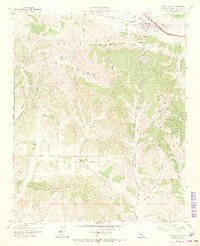
1959 Map of Los Alamos
USGS Topo · Published 1969About this map
Los Alamos sits at the northern edge of this late 1950s survey, a concentrated settlement within the agricultural Los Alamos Valley. The map details a complex landscape of canyon and ridge topography, where the Purisima Hills and Santa Rita Hills are dissected by numerous drainage features such as Cañada de Santa Rosa and Drum Canyon Road. A network of unpaved infrastructure, including the Mail Road and various Jeep Trails, suggests a landscape primarily dedicated to ranching and resource management rather than dense residential development. To the south, the Santa Rita Valley is anchored by the Campbell settlement and the winding path of Santa Rita Road. This document illustrates the era's transition between traditional land grants and modern surveying, evidenced by the large-scale terrain labels like San Carlos De Jonata juxtaposed with precise bench marks and elevations.
Find a feature on this map
36 named features on this map. Tap any name to fly to it.
Don’t see what you’re looking for? This feature index may not catch every label — zoom into the map to look around manually.
Map Details
Editions of this 1959 Los Alamos Map
4 editions found
Other maps of this area

1905 · Lompoc
USGS Topo · 1:125,000

1942 · Lompoc
USGS Topo · 1:125,000

1942 · Lompoc
USGS Topo · 1:62,500

1942 · Santa Maria
USGS Topo · 1:62,500

1942 · Tepusquet Peak
USGS Topo · 1:62,500

1942 · Los Olivos
USGS Topo · 1:62,500

1943 · Los Olivos
USGS Topo · 1:62,500

1943 · Tepusquet Peak
USGS Topo · 1:62,500

1943 · Lompoc
USGS Topo · 1:125,000

1947 · Lompoc
USGS Topo · 1:24,000