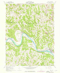
1961 Map of Lowell
USGS Topo · Published 1976About this map
The Muskingum River meanders through a landscape defined by sharp ridges and deep runs in this 1961 survey of Washington and Morgan counties. The settlement of Lowell serves as a focal point along the riverbank, accompanied by the smaller hamlets of Upper Lowell and Coal Run. The region's social history is recorded through numerous family and community landmarks, including the Old German Cem, the Townhouse Sch, and Our Lady of Mercy Ch.
Find a feature on this map
58 named features on this map. Tap any name to fly to it.
Don’t see what you’re looking for? This feature index may not catch every label — zoom into the map to look around manually.
Map Details
Editions of this 1961 Lowell Map
4 editions found
Other maps of this area

1902 · Parkersburg
USGS Topo · 1:62,500

1903 · Macksburg
USGS Topo · 1:62,500

1904 · Parkersburg
USGS Topo · 1:62,500

1904 · Marietta
USGS Topo · 1:62,500

1905 · Macksburg
USGS Topo · 1:62,500

1909 · Caldwell
USGS Topo · 1:62,500

1912 · Caldwell
USGS Topo · 1:62,500

1924 · Marietta
USGS Topo · 1:62,500

1927 · Marietta
USGS Topo · 1:62,500

1949 · Clarksburg
USGS Topo · 1:250,000