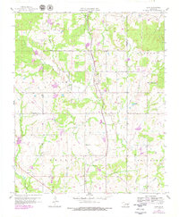
1958 Map of Lula
USGS Topo · Published 1979About this map
Lula and the surrounding rural townships sit at the intersection of the Missouri Pacific railroad and a network of creeks in south-central Oklahoma. This 1958 survey, updated with late-1970s photorevisions, shows a landscape defined by its water and industry, with a long Aqueduct and Pipeline cutting through the terrain. The presence of Oil Wells scattered near Bois d'Arc Creek highlights the local extraction economy, while the Indian Boundary line crossing north-to-south remains a significant surveyor's landmark.
Find a feature on this map
24 named features on this map. Tap any name to fly to it.
Don’t see what you’re looking for? This feature index may not catch every label — zoom into the map to look around manually.
Map Details
Editions of this 1958 Lula Map
3 editions found
Other maps of this area

1896 · Coalgate
USGS Topo · 1:125,000

1899 · Coalgate
USGS Topo · 1:125,000

1900 · Coalgate
USGS Topo · 1:125,000

1901 · Stonewall
USGS Topo · 1:125,000

1957 · Stonewall
USGS Topo · 1:24,000

1957 · Centrahoma
USGS Topo · 1:24,000

1957 · Tupelo NE
USGS Topo · 1:24,000

1957 · Ardmore
USGS Topo · 1:250,000

1958 · Lula
USGS Topo · 1:24,000

1958 · Francis
USGS Topo · 1:24,000