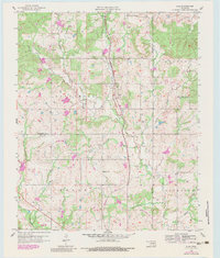
1958 Map of Lula
USGS Topo · Published 1983About this map
Lula and the surrounding terrain of the Pontotoc and Coal County line are captured in this mid-century survey, which reveals a landscape defined by small rural settlements and an evolving transportation network. The Missouri Pacific rail line cuts through the southern reaches, while the presence of an Old Railroad Grade north of Bois d' Arc Creek points to earlier logistical corridors. Local life is anchored by family and community landmarks such as Lula Cem, Pleasant Grove Cem, and Rocky Point Ch, while the industrial footprint of the era is marked by scattered Oil Wells and an aqueduct project. The drainage of Leader Creek and Sandy Creek shapes the geography, documenting a period when these small Oklahoma outposts served as critical hubs for the local agricultural and extractive economy.
Find a feature on this map
26 named features on this map. Tap any name to fly to it.
Don’t see what you’re looking for? This feature index may not catch every label — zoom into the map to look around manually.
Map Details
Editions of this 1958 Lula Map
3 editions found
Other maps of this area

1896 · Coalgate
USGS Topo · 1:125,000

1899 · Coalgate
USGS Topo · 1:125,000

1900 · Coalgate
USGS Topo · 1:125,000

1901 · Stonewall
USGS Topo · 1:125,000

1957 · Stonewall
USGS Topo · 1:24,000

1957 · Centrahoma
USGS Topo · 1:24,000

1957 · Tupelo NE
USGS Topo · 1:24,000

1957 · Ardmore
USGS Topo · 1:250,000

1958 · Lula
USGS Topo · 1:24,000

1958 · Francis
USGS Topo · 1:24,000