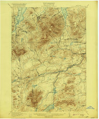
1913 Map of Lyon Mountain
USGS Topo · Published 1921About this map
Lyon Mountain anchors this Adirondack landscape at a time when the mining settlement and nearby Standish were central to the region's industrial activity. The survey illustrates the complex relationship between the rugged terrain and the Saranac River system, which flows through Clayburg and Redford. This river network, along with the North Branch Saranac River, provided the necessary water power for operations like the Goodrich Mill located near the southern map boundary.
Find a feature on this map
76 named features on this map. Tap any name to fly to it.
Don’t see what you’re looking for? This feature index may not catch every label — zoom into the map to look around manually.
Map Details
Editions of this 1913 Lyon Mountain Map
5 editions found

Other maps of this area

1895 · Mooers
USGS Topo · 1:62,500

1895 · Ausable
USGS Topo · 1:62,500

1896 · Lake Placid
USGS Topo · 1:62,500

1898 · Lake Placid
USGS Topo · 1:62,500

1899 · Mooers
USGS Topo · 1:62,500

1902 · Saranac
USGS Topo · 1:62,500

1903 · Ausable
USGS Topo · 1:62,500

1904 · Saranac
USGS Topo · 1:62,500

1906 · Loon Lake
USGS Topo · 1:62,500

1908 · Loon Lake
USGS Topo · 1:62,500