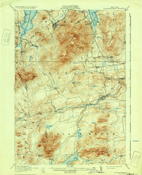
1913 Map of Lyon Mountain
USGS Topo · Published 1931About this map
The iron mining and timber industries of the northern Adirondacks define this landscape, anchored by the industrial center at Lyon Mountain and the iron-smelting operations nearby. The Delaware and Hudson railroad tracks wind through the mountains to reach Standish, connecting these mountain outposts to wider markets. Evidence of early industrial activity is visible at the Junction Kilns and the Goodrich Mill in the southeast.
Find a feature on this map
66 named features on this map. Tap any name to fly to it.
Don’t see what you’re looking for? This feature index may not catch every label — zoom into the map to look around manually.
Map Details
Editions of this 1913 Lyon Mountain Map
5 editions found

Other maps of this area

1895 · Mooers
USGS Topo · 1:62,500

1895 · Ausable
USGS Topo · 1:62,500

1896 · Lake Placid
USGS Topo · 1:62,500

1898 · Lake Placid
USGS Topo · 1:62,500

1899 · Mooers
USGS Topo · 1:62,500

1902 · Saranac
USGS Topo · 1:62,500

1903 · Ausable
USGS Topo · 1:62,500

1904 · Saranac
USGS Topo · 1:62,500

1906 · Loon Lake
USGS Topo · 1:62,500

1908 · Loon Lake
USGS Topo · 1:62,500