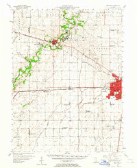
1957 Map of Mahomet
USGS Topo · Published 1964About this map
The Sangamon River meanders through this mid-century landscape, anchoring a region defined by the intersection of fertile prairie and burgeoning academic and transit hubs. The urban expansion of Champaign is visible in the east, characterized by the sprawling University of Illinois campus and the industrial infrastructure of the Illinois Central and Illinois Terminal railroads. This era shows a community in transition, where legacy one-room schoolhouses like Hensley Sch and Standard Sch (Abandoned) sit near the modern Illinois University Airport.
Find a feature on this map
71 named features on this map. Tap any name to fly to it.
Don’t see what you’re looking for? This feature index may not catch every label — zoom into the map to look around manually.
Map Details
Editions of this 1957 Mahomet Map
2 editions found

Other maps of this area

1906 · Urbana
USGS Topo · 1:62,500

1907 · Mahomet
USGS Topo · 1:62,500

1924 · Paxton
USGS Topo · 1:62,500

1927 · Paxton
USGS Topo · 1:62,500

1928 · Gibson City
USGS Topo · 1:62,500

1937 · Monticello
USGS Topo · 1:48,000

1943 · Monticello
USGS Topo · 1:62,500

1949 · Paxton
USGS Topo · 1:62,500

1950 · Tuscola
USGS Topo · 1:62,500

1952 · Arrowsmith
USGS Topo · 1:62,500