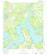
1968 Map of Mansfield Dam
USGS Topo · Published 1975About this map
The winding waters of Lake Travis dominate this 1968 landscape, following the completion of the Mansfield Dam and the creation of a massive recreational and power network. The map captures the early development of lakeside communities like Jonestown, Lago Vista, and Volente, alongside established rural landmarks. Family history remains visible at the Simpson Cem near Arkansas Bend and the Teck Cem tucked away inland. The geography is defined by a series of dramatic peninsulas and sheltered inlets, including Hudson Bend and Anderson Bend, while the lower reach shows the Colorado River Lake Austin below the dam. Inland from the shoreline, the topography rises sharply toward Post Oak Ridge and Bald Mountain, punctuated by numerous named hollows and several small aviation facilities such as the Bar K Landing Strip.
Find a feature on this map
64 named features on this map. Tap any name to fly to it.
Don’t see what you’re looking for? This feature index may not catch every label — zoom into the map to look around manually.
Map Details
Editions of this 1968 Mansfield Dam Map
Other maps of this area

1887 · Blanco
USGS Topo · 1:125,000

1887 · Burnet
USGS Topo · 1:125,000

1893 · Georgetown
USGS Topo · 1:125,000

1893 · Burnet
USGS Topo · 1:125,000

1894 · Blanco
USGS Topo · 1:125,000

1896 · Austin
USGS Topo · 1:125,000

1897 · Austin
USGS Topo · 1:125,000

1903 · Burnet
USGS Topo · 1:125,000

1909 · Burnet
USGS Topo · 1:125,000

1910 · Austin
USGS Topo · 1:125,000