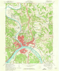
1969 Map of Marietta
USGS Topo · Published 1971About this map
Marietta sits at the strategic confluence of the Muskingum River and the Ohio River, serving as a historic river-hub on this late 1960s survey. The landscape is densely packed with sites of genealogical interest, including the Mound Cem, Old St Marys Cem, and Putnam Cem. Education and civic history are prominent through the Marietta College campus, the Campus Martius Museum, and the Courthouse downtown. Across the water, Williamstown, West Virginia, mirrors the development on the Ohio side, linked by the infrastructure of the Baltimore and Ohio railroad. Moving away from the urban center, the map transitions into the Wayne National Forest and industrial pockets like the Gravel Pits near Devola. The intricate river shoreline, including Buckley Island and Muskingum Island, illustrates the geographic constraints that shaped the growth of Harmar and Norwood.
Find a feature on this map
84 named features on this map. Tap any name to fly to it.
Don’t see what you’re looking for? This feature index may not catch every label — zoom into the map to look around manually.
Map Details
Editions of this 1969 Marietta Map
3 editions found
Other maps of this area

1902 · Parkersburg
USGS Topo · 1:62,500

1903 · Macksburg
USGS Topo · 1:62,500

1904 · Parkersburg
USGS Topo · 1:62,500

1904 · Marietta
USGS Topo · 1:62,500

1905 · Macksburg
USGS Topo · 1:62,500

1909 · Caldwell
USGS Topo · 1:62,500

1912 · Caldwell
USGS Topo · 1:62,500

1924 · Marietta
USGS Topo · 1:62,500

1927 · Marietta
USGS Topo · 1:62,500

1949 · Clarksburg
USGS Topo · 1:250,000