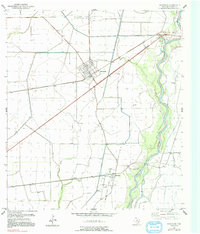
1952 Map of Markham
USGS Topo · Published 1991About this map
The North Markham Oil Field anchors the northern landscape of this survey, illustrating the industrial footprint of petroleum production in Matagorda County during the mid-20th century. The settlement of Markham serves as the primary hub, characterized by a structured grid of streets positioned west of the Colorado River. This river corridor is heavily managed, featuring an extensive system of Levee protections and technical infrastructure like the Pumping Station and Gaging Station near the river bend.
Find a feature on this map
14 named features on this map. Tap any name to fly to it.
Don’t see what you’re looking for? This feature index may not catch every label — zoom into the map to look around manually.
Map Details
Editions of this 1952 Markham Map
2 editions found
Other maps of this area

1950 · Houston
USGS Topo · 1:250,000

1951 · Bay City
USGS Topo · 1:250,000

1951 · Danevang
USGS Topo · 1:24,000

1952 · Lane City SE
USGS Topo · 1:24,000

1952 · Blessing SE
USGS Topo · 1:24,000

1952 · Blessing
USGS Topo · 1:24,000

1952 · Bay City
USGS Topo · 1:24,000

1952 · Markham
USGS Topo · 1:24,000

1952 · Van Vleck
USGS Topo · 1:24,000

1952 · Midfield
USGS Topo · 1:24,000