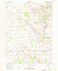
1960 Map of Marseilles
USGS Topo · Published 1972About this map
Marseilles sits as a primary settlement within this 1960 survey, situated at the bend where Tymochtee Creek meets its smaller tributary, Little Tymochtee Creek. The landscape is defined by the agricultural divisions of the Congress Lands, marked by a rigorous grid of section lines and rural roadways like Robinson Road and Wolfe Road. The survey reveals the intersection of early pioneer history and mid-century rural life, preserved in the alignment of the Old Indian Treaty Bdy which cuts across the northern townships.
Find a feature on this map
12 named features on this map. Tap any name to fly to it.
Don’t see what you’re looking for? This feature index may not catch every label — zoom into the map to look around manually.
Map Details
Editions of this 1960 Marseilles Map
4 editions found
Other maps of this area

1905 · Arlington
USGS Topo · 1:62,500

1907 · Arlington
USGS Topo · 1:24,000

1907 · Upper Sandusky
USGS Topo · 1:62,500

1915 · Kenton
USGS Topo · 1:62,500

1915 · La Rue
USGS Topo · 1:62,500

1944 · Kenton
USGS Topo · 1:62,500

1950 · Marion
USGS Topo · 1:250,000

1960 · Upper Sandusky
USGS Topo · 1:24,000

1960 · Marseilles
USGS Topo · 1:24,000
1961 · Meeker
USGS Topo · 1:24,000