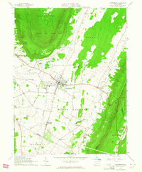
1963 Map of Martinsburg
USGS Topo · Published 1964About this map
Martinsburg and its surrounding valleys are defined by a distinct agricultural and industrial landscape bounded by the prominent ridges of Loop Mountain, Lock Mountain, and Tussey Mountain. The map illustrates a well-developed network of small rural settlements and religious sites, including Smithfield Ch, Diehls Crossroads Ch, and several family-named burial grounds like the Detwiler Cem and Stonerook Cem. The infrastructure of the early 1960s is evident in the presence of the Altoona-Blair County Airport and the Pennsylvania rail lines connecting Martinsburg Junction to Curryville. This survey uniquely documents the transition from rail-dependent commerce to a landscape increasingly shaped by automotive transport and aviation, while preserving the location of numerous country schools and churches that served the agricultural community of North Woodbury.
Find a feature on this map
55 named features on this map. Tap any name to fly to it.
Don’t see what you’re looking for? This feature index may not catch every label — zoom into the map to look around manually.
Map Details
Editions of this 1963 Martinsburg Map
3 editions found
Other maps of this area

1900 · Everett
USGS Topo · 1:62,500

1901 · Huntingdon
USGS Topo · 1:62,500

1902 · Everett
USGS Topo · 1:62,500

1902 · Hollidaysburg
USGS Topo · 1:62,500

1903 · Hollidaysburg
USGS Topo · 1:62,500

1904 · Huntingdon
USGS Topo · 1:62,500

1930 · Broad Top
USGS Topo · 1:62,500

1933 · Broad Top
USGS Topo · 1:62,500

1953 · Pittsburgh
USGS Topo · 1:250,000

1954 · Pittsburgh
USGS Topo · 1:250,000