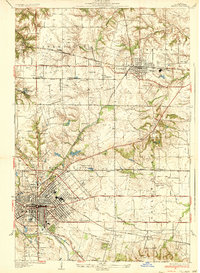
1954 Map of Mascoutah
USGS Topo · Published 1969About this map
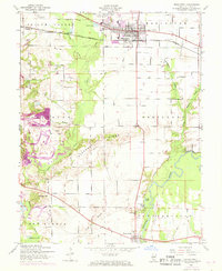
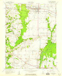
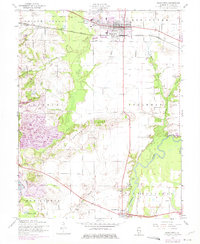
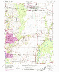
Mascoutah and the surrounding Shiloh Valley reflect an Illinois landscape undergoing significant industrial change by the late 1960s. While the area retains its agricultural character through family-named landmarks like Haubers Hill and Mueller Cem, the western sections show the impact of extractive industries. Large Strip Mine operations and associated Tailings Ponds dominate the area around Freeburg, marking the shift toward coal production. The Louisville and Nashville railroad serves as a central artery for the region, connecting smaller hubs like Rentchler to the larger town. Along the southern edge, the Kaskaskia River and its oxbows, including Long Lake and Round Lake, define the terrain near Fayetteville. Numerous country cemeteries and chapels, such as Espenschied Chapel and Schneblin Cem, provide essential data for those tracing local family histories and early settlement patterns.
Find a feature on this map
45 named features on this map. Tap any name to fly to it.
Don’t see what you’re looking for? This feature index may not catch every label — zoom into the map to look around manually.
Map Details
Editions of this 1954 Mascoutah Map
4 editions found
Other maps of this area

1906 · Breese
USGS Topo · 1:62,500

1907 · Breese
USGS Topo · 1:62,500

1907 · Belleville
USGS Topo · 1:62,500

1910 · Okawville
USGS Topo · 1:62,500

1912 · New Athens
USGS Topo · 1:62,500
1935 · Lebanon
USGS Topo · 1:24,000
1937 · O'Fallon
USGS Topo · 1:24,000

1940 · Okawville
USGS Topo · 1:62,500
1949 · Lebanon
USGS Topo · 1:24,000
1954 · Freeburg
USGS Topo · 1:24,000