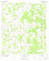
1955 Map of Mayo NE
USGS Topo · Published 1977About this map
Suwannee County rural life centers on a network of small churches and community schools during the mid-1950s. The landscape is characterized by its organized grid of sections and diverse vegetation, where local congregation sites like Claywood Ch and Friendship Ch provide focal points for the surrounding farmsteads. Genealogical interest is high in this quadrangle, as several family-named or community burial grounds are documented, including Claywood Cem, Smith Cem, and Mt Willing Cem. The presence of dual-purpose sites such as Shiloh Sch and St James Sch illustrates the era's reliance on localized educational and religious centers. This survey, compiled from 1951 aerial photography and finished via planetable in 1955, preserves the layout of unimproved dirt roads and light-duty paths that connected these Suwannee County communities before modern development altered the rural interior.
Find a feature on this map
12 named features on this map. Tap any name to fly to it.
Don’t see what you’re looking for? This feature index may not catch every label — zoom into the map to look around manually.
Map Details
Editions of this 1955 Mayo NE Map
3 editions found
Other maps of this area

1954 · Dowling Park
USGS Topo · 1:24,000

1954 · Valdosta
USGS Topo · 1:250,000

1955 · Mayo NE
USGS Topo · 1:24,000

1955 · Mayo
USGS Topo · 1:24,000

1955 · Mayo SE
USGS Topo · 1:24,000

1958 · Valdosta
USGS Topo · 1:250,000

1959 · Valdosta
USGS Topo · 1:250,000

1959 · Live Oak West
USGS Topo · 1:24,000

1959 · Falmouth
USGS Topo · 1:24,000

1961 · Live Oak East
USGS Topo · 1:24,000