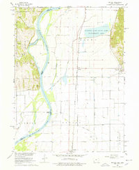
1966 Map of Mc Paul
USGS Topo · Published 1978About this map
The Missouri River forms a dynamic boundary in this mid-1960s survey, separating Nebraska and Iowa as it winds through a landscape of fertile bottomlands and prominent bluffs. The river's historical shifts are evident in features like Wa-Con-Da Lake, West Chute, and East Chute, reflecting the complex hydrology of the Missouri River Basin. On the Iowa side, the Chicago Burlington and Quincy railroad line anchors local transportation, connecting the small settlements of McPaul and Percival. Cultural and genealogical markers are well-preserved across the townships of Liberty, Scott, and Benton, including the Ervine Sch and several local burial grounds like Eatons Cem. To the east, the East Rock Bluffs rise above the floodplain, providing a contrast to the extensive drainage networks of the Plum Creek Ditch and the protected habitat of the Forneys Lake State Game Management Area.
Find a feature on this map
40 named features on this map. Tap any name to fly to it.
Don’t see what you’re looking for? This feature index may not catch every label — zoom into the map to look around manually.
Map Details
Editions of this 1966 Mc Paul Map
3 editions found
Other maps of this area

1907 · Nebraska City
USGS Topo · 1:62,500

1935 · Nehawka
USGS Topo · 1:48,000

1939 · Hamburg
USGS Topo · 1:62,500

1940 · Nehawka
USGS Topo · 1:62,500

1941 · Hamburg
USGS Topo · 1:62,500

1955 · Nebraska City
USGS Topo · 1:250,000

1956 · Murray
USGS Topo · 1:24,000

1956 · Rock Bluff
USGS Topo · 1:24,000

1957 · Nebraska City
USGS Topo · 1:250,000

1957 · Tabor
USGS Topo · 1:24,000