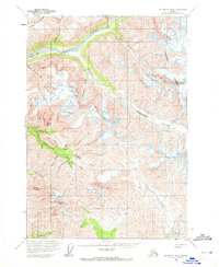
1959 Map of McCarthy B-4
USGS Topo · Published 1972About this map
The Chitistone River valley and its surrounding peaks define this high-altitude landscape in the Wrangell Mountains. Recorded in the late 1950s, the map highlights a region shaped by ice and mineral exploration, featuring the massive Twaharpies Glacier and the University Range. Human activity is primarily centered on remote mining operations and the infrastructure required to access them. Evidence of this includes the Nelson Prospect and Radovan Prospect, which are linked to lower elevations via the Radovan Tramway. Aviation also plays a critical role in this isolated environment, as seen with the Glacier Creek Landing Strip. The presence of a Placer Mine on Texas Creek and scattered Cabins suggests a cycle of seasonal work and prospecting near Lime Butte and Dan Creek, far from established towns.
Find a feature on this map
40 named features on this map. Tap any name to fly to it.
Don’t see what you’re looking for? This feature index may not catch every label — zoom into the map to look around manually.
Map Details
Editions of this 1959 McCarthy B-4 Map
3 editions found
Other maps of this area

1951 · McCarthy
USGS Topo · 1:250,000

1959 · McCarthy A-4
USGS Topo · 1:63,360

1959 · McCarthy C-5
USGS Topo · 1:63,360

1959 · McCarthy B-5
USGS Topo · 1:63,360

1959 · McCarthy C-4
USGS Topo · 1:63,360

1959 · McCarthy B-4
USGS Topo · 1:63,360

1959 · McCarthy C-3
USGS Topo · 1:63,360

1959 · McCarthy A-5
USGS Topo · 1:63,360

1959 · McCarthy A-3
USGS Topo · 1:63,360

1959 · McCarthy B-3
USGS Topo · 1:63,360