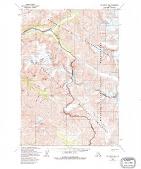
1959 Map of McCarthy B-4
USGS Topo · Published 1995About this map
Chitistone River carves through the high terrain of the Wrangell Mountains, serving as a central artery for the mining and exploration recorded in this 1950s era survey. The landscape is defined by its industrial potential, with multiple mineral claims situated along the steep gulches, including the Nelson Prospect, Radovan Prospect, and Erickson Prospect. A specialized infrastructure for extraction is evident near Texas Creek, where an Aerial Tramway and Placer Mine are noted. Access to this remote district was facilitated by the Glacier Creek Landing Strip, located on the broad gravels of Peavine Bar. From the heights of Joshua Green Peak to the icy expanse of Rex Glacier, the map details a region where prospectors established small camps and Cabins to support their work in the drainage of Dan Creek and its surrounding peaks.
Find a feature on this map
41 named features on this map. Tap any name to fly to it.
Don’t see what you’re looking for? This feature index may not catch every label — zoom into the map to look around manually.
Map Details
Editions of this 1959 McCarthy B-4 Map
3 editions found
Other maps of this area

1951 · McCarthy
USGS Topo · 1:250,000

1959 · McCarthy A-4
USGS Topo · 1:63,360

1959 · McCarthy C-5
USGS Topo · 1:63,360

1959 · McCarthy B-5
USGS Topo · 1:63,360

1959 · McCarthy C-4
USGS Topo · 1:63,360

1959 · McCarthy B-4
USGS Topo · 1:63,360

1959 · McCarthy C-3
USGS Topo · 1:63,360

1959 · McCarthy A-5
USGS Topo · 1:63,360

1959 · McCarthy A-3
USGS Topo · 1:63,360

1959 · McCarthy B-3
USGS Topo · 1:63,360