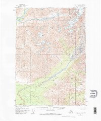
1951 Map of McCarthy C-8
USGS Topo · Published 1977About this map
The Kuskulana River and its massive Kuskulana Glacier dominate this Alaskan landscape, where glacial waters feed a complex network of drainages including the Kotsina River and Kluvesna River. Small clusters of cabins along the rivers and a solitary trail suggest a landscape used for seasonal prospecting or trapping in the mid-20th century. High-altitude landmarks like Skyscraper Peak and Granite Peak provide orientation for navigating the terrain between Dixie Pass and Kuskulana Pass. The presence of Mac Dougall and several unnamed cabins indicates specific points of localized activity near the confluence of Clear Creek and Sheep Creek. This 1951 field-annotated map serves as a record of the drainage patterns and peaks long before significant modern infrastructure reached this part of the Copper River Meridian.
Find a feature on this map
32 named features on this map. Tap any name to fly to it.
Don’t see what you’re looking for? This feature index may not catch every label — zoom into the map to look around manually.
Map Details
Editions of this 1951 McCarthy C-8 Map
4 editions found
Other maps of this area

1951 · McCarthy
USGS Topo · 1:250,000

1951 · Valdez B-1
USGS Topo · 1:63,360

1951 · McCarthy C-8
USGS Topo · 1:63,360

1951 · McCarthy B-8
USGS Topo · 1:63,360

1951 · Valdez C-1
USGS Topo · 1:63,360

1952 · Valdez
USGS Topo · 1:250,000

1953 · Valdez C-1
USGS Topo · 1:63,360

1959 · Valdez D-1
USGS Topo · 1:63,360

1959 · McCarthy D-7
USGS Topo · 1:63,360

1959 · McCarthy C-7
USGS Topo · 1:63,360