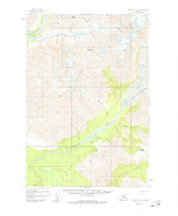
1951 Map of McCarthy C-8
USGS Topo · Published 1977About this map
The glacial and fluvial drainage systems of the Wrangell Mountains dominate this 1950s-era topographic study. The Kuskulana Glacier serves as the primary headwater for the Kuskulana River, which carves south through the center of the sheet. High-altitude landmarks like Skyscraper Peak and Granite Peak overlook a network of gold-bearing drainages including Nugget Creek and Porcupine Creek. Small clusters of Cabins are noted along the banks of the Kuskulana River and Mac Dougall Creek, indicating the scattered presence of trappers or prospectors in this demanding environment. In the northwest, the Kluvesna River creates a unique landform known as The Peninsula. Further south, a lone Trail traverses the valley floor, connecting the riparian zones of Slatka Creek and the Chokosna River.
Find a feature on this map
38 named features on this map. Tap any name to fly to it.
Don’t see what you’re looking for? This feature index may not catch every label — zoom into the map to look around manually.
Map Details
Editions of this 1951 McCarthy C-8 Map
4 editions found
Other maps of this area

1951 · McCarthy
USGS Topo · 1:250,000

1951 · Valdez B-1
USGS Topo · 1:63,360

1951 · McCarthy C-8
USGS Topo · 1:63,360

1951 · McCarthy B-8
USGS Topo · 1:63,360

1951 · Valdez C-1
USGS Topo · 1:63,360

1952 · Valdez
USGS Topo · 1:250,000

1953 · Valdez C-1
USGS Topo · 1:63,360

1959 · Valdez D-1
USGS Topo · 1:63,360

1959 · McCarthy D-7
USGS Topo · 1:63,360

1959 · McCarthy C-7
USGS Topo · 1:63,360