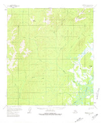
1958 Map of Medfra C-2
USGS Topo · Published 1981About this map
The North Fork Kuskokwim River defines the southeastern drainage of this interior Alaskan landscape, where the meandering waterway gives way to a complex network of streams and marshy lowlands. High ground is marked by the Sischu Mountains to the north and Stone Mountain to the west, separated by the narrow corridor of Pass Creek. Human presence in the late 1950s was minimal and temporary, primarily consisting of isolated structures like Stones Cabins and a lone Cabin located near the riverbank. This map captures a remote frontier environment where transportation was dictated by seasonal conditions, evidenced by the presence of a Winter Trail cutting across the northeastern terrain near Little Hog Butte. Numerous named waterways, including Rungun Creek and Hardscrabble Creek, suggest a landscape well-known to local trappers or surveyors who navigated the dense drainage basins.
Find a feature on this map
18 named features on this map. Tap any name to fly to it.
Don’t see what you’re looking for? This feature index may not catch every label — zoom into the map to look around manually.
Map Details
Editions of this 1958 Medfra C-2 Map
2 editions found
Other maps of this area

1950 · Medfra
USGS Topo · 1:250,000
1954 · Medfra D-3
USGS Topo · 1:63,360

1954 · Medfra C-3
USGS Topo · 1:63,360

1955 · Medfra B-3
USGS Topo · 1:63,360

1958 · Medfra D-2
USGS Topo · 1:63,360

1958 · Medfra C-2
USGS Topo · 1:63,360

1958 · Medfra B-2
USGS Topo · 1:63,360

1958 · Medfra C-1
USGS Topo · 1:63,360

1958 · Medfra D-1
USGS Topo · 1:63,360

1958 · Medfra B-1
USGS Topo · 1:63,360