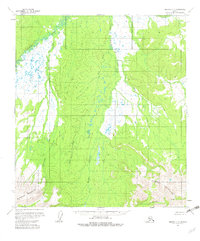
1953 Map of Medfra C-4
USGS Topo · Published 1982About this map
The Mystery Mountains and the Sunshine Mountains anchor this interior Alaskan landscape, which remains largely untouched by infrastructure in the mid-1950s. The region is defined by a dense network of waterways, most notably the meandering Nowitna River in the northwest. Numerous drainages such as Clearwater Creek, Meadow Creek, and Fire Creek flow through the valleys, illustrating the complex hydrology of the Kuskokwim River watershed. A lone Cabin near the northern boundary stands as the only named structure, suggesting a landscape used primarily for seasonal trapping, hunting, or early geological exploration. This 1953 survey, based on aerial photography, provides a clear view of the unsurveyed wilderness before any formal roads or trails were established in this part of the Yukon-Koyukuk region.
Find a feature on this map
9 named features on this map. Tap any name to fly to it.
Don’t see what you’re looking for? This feature index may not catch every label — zoom into the map to look around manually.
Map Details
Editions of this 1953 Medfra C-4 Map
3 editions found
Other maps of this area

1950 · Medfra
USGS Topo · 1:250,000

1953 · Medfra B-4
USGS Topo · 1:63,360

1953 · Medfra B-5
USGS Topo · 1:63,360

1953 · Medfra C-4
USGS Topo · 1:63,360

1954 · Medfra C-5
USGS Topo · 1:63,360

1954 · Medfra D-5
USGS Topo · 1:63,360
1954 · Medfra D-3
USGS Topo · 1:63,360

1954 · Medfra C-3
USGS Topo · 1:63,360
1954 · Medfra D-4
USGS Topo · 1:63,360

1955 · Medfra B-3
USGS Topo · 1:63,360