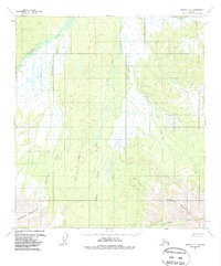
1953 Map of Medfra C-4
USGS Topo · Published 1987About this map
The Nowitna River meanders through the northwest corner of this Interior Alaska landscape, establishing a drainage network that defines the region's topography. Based on aerial photography from the mid-1950s, the map reveals a wilderness largely devoid of permanent human infrastructure, with a single Cabin positioned near the riverbank as a solitary marker of residency or seasonal use. To the south, the terrain ascends sharply into the Sunshine Mountains and the formidable Mystery Mountains, where elevations rise to over 3,000 feet. A series of parallel waterways, including Clearwater Creek, Fire Creek, and Meadow Creek, flow northward from these heights toward the Nowitna. This survey documents the area before significant modern modification, preserving the original names of remote features like Canyon Creek and Cottonwood Creek in a territory primarily managed by the Bureau of Land Management.
Find a feature on this map
10 named features on this map. Tap any name to fly to it.
Don’t see what you’re looking for? This feature index may not catch every label — zoom into the map to look around manually.
Map Details
Editions of this 1953 Medfra C-4 Map
3 editions found
Other maps of this area

1950 · Medfra
USGS Topo · 1:250,000

1953 · Medfra B-4
USGS Topo · 1:63,360

1953 · Medfra B-5
USGS Topo · 1:63,360

1953 · Medfra C-4
USGS Topo · 1:63,360

1954 · Medfra C-5
USGS Topo · 1:63,360

1954 · Medfra D-5
USGS Topo · 1:63,360
1954 · Medfra D-3
USGS Topo · 1:63,360

1954 · Medfra C-3
USGS Topo · 1:63,360
1954 · Medfra D-4
USGS Topo · 1:63,360

1955 · Medfra B-3
USGS Topo · 1:63,360