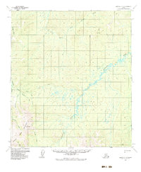
1954 Map of Medfra C-6
USGS Topo · Published 1983About this map
Susulatna River and the North Fork Innoko River wind through this interior Alaska landscape, defining a region where transportation relied heavily on seasonal routes and small-scale aviation. The presence of a Summer Trail cutting across the northern reaches and a designated Landing Strip near Colorado Creek underscores the logistical challenges of the mid-1950s. Near the western edge, a solitary Mine is located along the drainage of Creston Creek, hinting at the mineral extraction that historically drove exploration in the Yukon-Koyukuk region. In the southwest, the terrain rises significantly toward the Mountains at VABM 8272 Cripple, where Cripple Creek and Butte Creek originate. This map documents a largely unsurveyed wilderness where the Bureau of Land Management established land lines before physical markers were placed, preserving a view of the territory during its early aerial surveying phase.
Find a feature on this map
19 named features on this map. Tap any name to fly to it.
Don’t see what you’re looking for? This feature index may not catch every label — zoom into the map to look around manually.
Map Details
Editions of this 1954 Medfra C-6 Map
3 editions found
Other maps of this area

1950 · Medfra
USGS Topo · 1:250,000

1951 · Ophir
USGS Topo · 1:250,000

1953 · Medfra B-5
USGS Topo · 1:63,360

1954 · Medfra C-6
USGS Topo · 1:63,360

1954 · Medfra C-5
USGS Topo · 1:63,360

1954 · Medfra D-5
USGS Topo · 1:63,360

1954 · Medfra D-6
USGS Topo · 1:63,360

1954 · Medfra B-6
USGS Topo · 1:63,360
1954 · Ophir D-1
USGS Topo · 1:63,360

1954 · Ophir C-1
USGS Topo · 1:63,360