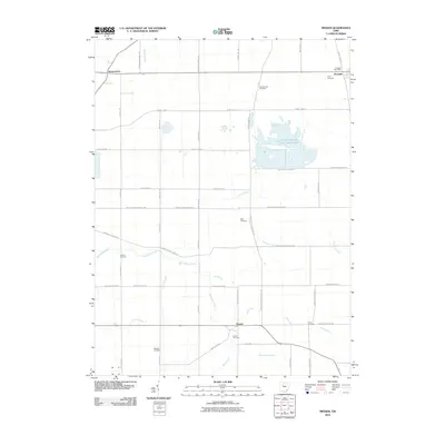
2010 Map of Meeker
USGS Topo · Published 2010About this map
The agricultural landscape of Pitt Township is defined by a rigorous grid of section lines and the winding course of Tymochtee Creek. This 2010 survey highlights the rural community of Meeker and the town of Harpster, where the Harpster Post Office remains a central landmark. The map is a valuable resource for genealogists, as it identifies numerous small family and community burial grounds across the countryside, including the Hunt Cemetery, Bowsherville Cemetery, Deal Cemetery, and Yoakum Cemetery. Water management is a visible priority here, seen in the drainage of Carroll Ditch and the expansive Killdeer Wildlife Pond Number One to the north. Smaller settlements like Brownstown anchor the western edge of the quadrangle, connected by a network of county roads that have shaped the development of Wyandot County for generations.
Find a feature on this map
47 named features on this map. Tap any name to fly to it.
Don’t see what you’re looking for? This feature index may not catch every label — zoom into the map to look around manually.
Map Details
Editions of this 2010 Meeker Map
This is the sole edition of this map. No revisions or reprints were ever made.
Other maps of this area

1903 · Marion
USGS Topo · 1:62,500

1905 · Marion
USGS Topo · 1:62,500

1906 · Sycamore
USGS Topo · 1:62,500

1907 · Upper Sandusky
USGS Topo · 1:62,500

1915 · La Rue
USGS Topo · 1:62,500

1950 · Marion
USGS Topo · 1:250,000

1960 · Nevada
USGS Topo · 1:24,000
1960 · Morral
USGS Topo · 1:24,000

1960 · Upper Sandusky
USGS Topo · 1:24,000

1960 · Marseilles
USGS Topo · 1:24,000