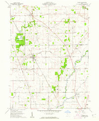
1960 Map of Morral
USGS Topo · Published 1962About this map
The Old Indian Treaty Boundary slices diagonally across this portion of Marion and Wyandot Counties, a reminder of early 19th-century land cessions that shaped the local grid. The landscape is defined by the Scioto River and the Little Sandusky River, where the Chesapeake and Ohio Road provides a primary rail artery for the agricultural settlements of Morral, Harpster, and Little Sandusky. This survey reveals a rural society structured around small communities and their local institutions, including the Ridgedale Sch and numerous burial grounds such as Macedonia Cem and Grand Prairie Cem. Notable industrial activity is indicated by a claypit near Morral and a quarry to the south. The sprawling Killdeer Plains Wildlife Area occupies a significant portion of the western terrain, preserving open space amidst the surrounding township fields of Salt Rock and Grand Prairie.
Find a feature on this map
36 named features on this map. Tap any name to fly to it.
Don’t see what you’re looking for? This feature index may not catch every label — zoom into the map to look around manually.
Map Details
Editions of this 1960 Morral Map
Other maps of this area

1903 · Marion
USGS Topo · 1:62,500

1905 · Marion
USGS Topo · 1:62,500

1906 · Sycamore
USGS Topo · 1:62,500

1907 · Upper Sandusky
USGS Topo · 1:62,500

1915 · La Rue
USGS Topo · 1:62,500

1950 · Marion
USGS Topo · 1:250,000

1960 · Oceola
USGS Topo · 1:24,000

1960 · Nevada
USGS Topo · 1:24,000

1960 · Upper Sandusky
USGS Topo · 1:24,000
1961 · Meeker
USGS Topo · 1:24,000