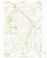
1960 Map of Morral
USGS Topo · Published 1972About this map
The Old Indian Treaty Boundary cuts a diagonal path across this central Ohio landscape, marking a significant historical line of demarcation near the village of Morral. In the early 1960s, the region was characterized by its structured grid of rural roads and the heavy influence of the Chesapeake and Ohio railroad, which bisects the townships of Pitt, Salt Rock, and Grand Prairie. The terrain is defined by the headwaters and branches of the Scioto River and Little Sandusky River, which drain the surrounding farmland and the Killdeer Plains Wildlife Area.
Find a feature on this map
47 named features on this map. Tap any name to fly to it.
Don’t see what you’re looking for? This feature index may not catch every label — zoom into the map to look around manually.
Map Details
Editions of this 1960 Morral Map
Other maps of this area

1903 · Marion
USGS Topo · 1:62,500

1905 · Marion
USGS Topo · 1:62,500

1906 · Sycamore
USGS Topo · 1:62,500

1907 · Upper Sandusky
USGS Topo · 1:62,500

1915 · La Rue
USGS Topo · 1:62,500

1950 · Marion
USGS Topo · 1:250,000

1960 · Oceola
USGS Topo · 1:24,000

1960 · Nevada
USGS Topo · 1:24,000
1960 · Morral
USGS Topo · 1:24,000

1960 · Upper Sandusky
USGS Topo · 1:24,000