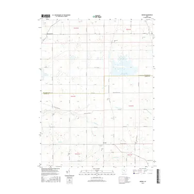
2016 Map of Meeker
USGS Topo · Published 2016About this map
The agrarian borderlands of Wyandot and Marion Counties are defined by a sophisticated drainage network and scattered pioneer burial grounds. The settlement of Meeker sits at a crossroads in the southern portion of the map, while Brownstown anchors the northwest corner. This landscape is a patchwork of rural township sections where modern water management, seen in the Killdeer Upground Reservoir and Killdeer Wildlife Pond Number Three, overlies the natural winding course of Tymochtee Cr. Local historians and genealogists will find an exceptional density of family and community cemeteries, including Hunt Cem, Bowsherville Cem, and Deal Cem. These sites, alongside landmarks like the Frame Cem near Meeker, provide a clear record of the families who settled this fertile Ohio territory, even as the landscape shifted from traditional stream-side farming toward large-scale water conservation and grid-based agricultural planning.
Find a feature on this map
103 named features on this map. Tap any name to fly to it.
Don’t see what you’re looking for? This feature index may not catch every label — zoom into the map to look around manually.
Map Details
Editions of this 2016 Meeker Map
This is the sole edition of this map. No revisions or reprints were ever made.
Other maps of this area

1903 · Marion
USGS Topo · 1:62,500

1905 · Marion
USGS Topo · 1:62,500

1906 · Sycamore
USGS Topo · 1:62,500

1907 · Upper Sandusky
USGS Topo · 1:62,500

1915 · La Rue
USGS Topo · 1:62,500

1950 · Marion
USGS Topo · 1:250,000

1960 · Nevada
USGS Topo · 1:24,000
1960 · Morral
USGS Topo · 1:24,000

1960 · Upper Sandusky
USGS Topo · 1:24,000

1960 · Marseilles
USGS Topo · 1:24,000