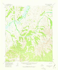
1953 Map of Melozitna A-4
USGS Topo · Published 1974About this map
The Melozitna River winds through the northern portion of this interior Alaskan landscape, dominated by the sweeping elevations of the Kokrines Hills. Surveyed in the early 1950s, the terrain shows a primitive wilderness environment where drainage patterns define the geography. One of the most notable human-recorded points is Melozit Springs (Aband), located along the eastern slopes above Glacier Creek. The label "Aband" (abandoned) provides a critical marker for those tracing the history of seasonal camps or early geological exploration in this part of the Kateel River Meridian. To the south, Hot Springs Creek and Black Sand Creek feed into the broader drainage system, while the singular label Turnaround at the southwestern corner suggests a known landmark or terminal point for river travel or early trails during this era of Alaskan mapping.
Find a feature on this map
7 named features on this map. Tap any name to fly to it.
Don’t see what you’re looking for? This feature index may not catch every label — zoom into the map to look around manually.
Map Details
Editions of this 1953 Melozitna A-4 Map
3 editions found
Other maps of this area

1951 · Ruby
USGS Topo · 1:250,000

1951 · Melozitna
USGS Topo · 1:250,000

1952 · Ruby D-4
USGS Topo · 1:63,360

1952 · Ruby D-5
USGS Topo · 1:63,360

1952 · Ruby D-3
USGS Topo · 1:63,360

1952 · Ruby
USGS Topo · 1:250,000

1953 · Melozitna A-4
USGS Topo · 1:63,360
1953 · Ruby D-4
USGS Topo · 1:63,360
1954 · Melozitna A-5
USGS Topo · 1:63,360

1954 · Melozitna B-3
USGS Topo · 1:63,360