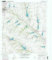
1961 Map of Midlothian
USGS Topo · Published 1979About this map
Midlothian serves as a major rail and transit hub in this mid-century portrait of Ellis County, where the Southern Pacific railroad cuts a diagonal path across the rolling landscape. The map captures a transition toward modern infrastructure while preserving the early footprint of rural life, evidenced by the distribution of family-named landmarks like Hawkins Spring and the Singleton Farm. To the southeast, the residential and institutional presence of Waxahachie and the United Presbyterian Homes contrast with the agricultural character of smaller communities such as Sardis and Lone Elm.
Find a feature on this map
26 named features on this map. Tap any name to fly to it.
Don’t see what you’re looking for? This feature index may not catch every label — zoom into the map to look around manually.
Map Details
Editions of this 1961 Midlothian Map
3 editions found
Other maps of this area

1891 · Dallas
USGS Topo · 1:125,000

1891 · Cleburne
USGS Topo · 1:125,000

1893 · Dallas
USGS Topo · 1:125,000

1894 · Cleburne
USGS Topo · 1:125,000

1894 · Fort Worth
USGS Topo · 1:125,000

1954 · Dallas
USGS Topo · 1:250,000

1958 · Dallas
USGS Topo · 1:250,000

1959 · Lancaster
USGS Topo · 1:24,000

1959 · Cedar Hill
USGS Topo · 1:24,000

1959 · Britton
USGS Topo · 1:24,000