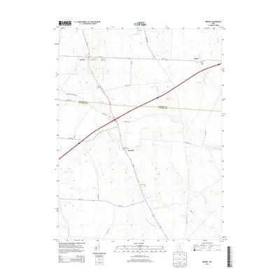
2013 Map of Midway
USGS Topo · Published 2013About this map
The boundary between Madison and Fayette counties anchors this agricultural landscape, where family-named cemeteries and rural settlements trace the lineage of local settlement. Several small communities, including Midway, Bethel, and Yatesville, are connected by a network of state roads like Oh-38 and Oh-323. The area is defined by its drainage patterns, featuring engineered waterways such as the William Cathcart Ditch and Valley Ditch, alongside natural flows like East Fork Paint Creek. Genealogists will find significant value in the distribution of burial sites across the township, from the centrally located Range Cem to the Union Chapel Cem and Vesey Cem. This 2013 survey illustrates a persistent agrarian character, noted by the presence of modern operations like Stardust Dairy and Bock Farms amidst a historic grid of country roads and creeks.
Find a feature on this map
44 named features on this map. Tap any name to fly to it.
Don’t see what you’re looking for? This feature index may not catch every label — zoom into the map to look around manually.
Map Details
Editions of this 2013 Midway Map
This is the sole edition of this map. No revisions or reprints were ever made.
Other maps of this area

1906 · Mt Sterling
USGS Topo · 1:62,500

1907 · London
USGS Topo · 1:62,500

1907 · South Charleston
USGS Topo · 1:62,500

1916 · Octa
USGS Topo · 1:62,500

1944 · Octa
USGS Topo · 1:62,500

1947 · Columbus
USGS Topo · 1:250,000

1961 · Columbus
USGS Topo · 1:250,000
1961 · Florence
USGS Topo · 1:24,000
1961 · Big Plain
USGS Topo · 1:24,000
1961 · Walnut Run
USGS Topo · 1:24,000