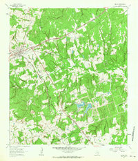
1962 Map of Milano
USGS Topo · Published 1964About this map
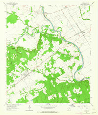
The junction of the Missouri Pacific and the Gulf Colorado and Santa Fe railroads defines the rail-centered character of Milano, Texas. This 1962 survey reveals a landscape etched by a dense network of watercourses, including Smyrna Creek and Yellow Rabbit Creek, flowing through the timbered hills of the Milam Co Burleson Co boundary region. The map highlights the rural social fabric of the era through sites like Sand Grove Ch, Friendship Ch, and the Sand Point Cem. Further south, the settlement of Elevation and the Newton Lakes reservoirs mark significant points of human activity and water management in the Brazos River basin. These details, alongside family-named landmarks like Hurt Cem and numerous unnamed gravel pits and drill holes, offer a look into the mid-century agricultural and industrial footprint of East Central Texas.
Find a feature on this map
36 named features on this map. Tap any name to fly to it.
Don’t see what you’re looking for? This feature index may not catch every label — zoom into the map to look around manually.
Map Details
Editions of this 1962 Milano Map
2 editions found
Other maps of this area

1954 · Austin
USGS Topo · 1:250,000

1956 · Caldwell
USGS Topo · 1:62,500

1956 · Milano
USGS Topo · 1:62,500
1961 · Caldwell
USGS Topo · 1:24,000

1961 · Hanover
USGS Topo · 1:24,000

1961 · Cameron
USGS Topo · 1:24,000

1961 · Rockdale East
USGS Topo · 1:24,000

1962 · Goodwill
USGS Topo · 1:24,000
1962 · Chriesman
USGS Topo · 1:24,000
1962 · Gause
USGS Topo · 1:24,000