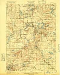
1909 Map of Milford
USGS Topo · Published 1920About this map
The Huron River winds through this glacial landscape, serving as the connective thread between several burgeoning rail settlements in the early twentieth century. This survey showcases a densely packed interior of rural education and commerce, where no fewer than twenty-two local schools, such as Brick School and Crafts School, served the farming families across Rose and Milford townships. The arrival of the Pere Marquette RR and the Grand Trunk RR transformed the region, fostering growth at Clyde and Wixom while older centers like Rose P.O. and Hollys Corners remained as established community anchors. Topographical details reveal a complex network of kettle lakes including White Lake and Duck Lake, which characterize the undulating terrain. Prominent landmarks like Haven Hill and Teeple Hill rise above the wetlands, defining the horizon for local residents long before the area's later suburban development.
Find a feature on this map
121 named features on this map. Tap any name to fly to it.
Don’t see what you’re looking for? This feature index may not catch every label — zoom into the map to look around manually.
Map Details
Editions of this 1909 Milford Map
4 editions found

Other maps of this area

1902 · South Lyon
USGS Topo · 1:62,500

1902 · Dexter
USGS Topo · 1:62,500

1904 · Ann Arbor
USGS Topo · 1:125,000

1905 · Wayne
USGS Topo · 1:62,500

1906 · Dexter
USGS Topo · 1:62,500

1906 · South Lyon
USGS Topo · 1:62,500

1907 · Pontiac
USGS Topo · 1:62,500

1907 · Howell
USGS Topo · 1:62,500

1908 · Ann Arbor
USGS Topo · 1:125,000

1909 · Howell
USGS Topo · 1:62,500
Featured Places
- Novi, MI
- Commerce Charter Township, MI
- White Lake Charter Township, MI
- Lyon Charter Township, MI
- Green Oak Charter Township, MI