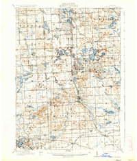
1909 Map of Milford
USGS Topo · Published 1934About this map
Milford sits at the heart of this glacial landscape, where the Huron River and various lake chains dictated the early development of western Oakland County. The map reveals an agrarian society organized around local schoolhouses such as Brick School, Pioneer School, and Stone School, each serving a small radius of family farms. Transport is defined by the Pere Marquette and Grand Trunk R R lines, which connected rural stops like Clyde and Highland to broader markets. Beyond the settlements, the terrain is dominated by a high density of kettle lakes and wetlands, including White Lake and Duck Lake, while The Bluffs and elevations like Haven Hill provide distinctive overlooks in an area otherwise shaped by water and woods.
Find a feature on this map
103 named features on this map. Tap any name to fly to it.
Don’t see what you’re looking for? This feature index may not catch every label — zoom into the map to look around manually.
Map Details
Editions of this 1909 Milford Map
4 editions found

Other maps of this area

1902 · South Lyon
USGS Topo · 1:62,500

1902 · Dexter
USGS Topo · 1:62,500

1904 · Ann Arbor
USGS Topo · 1:125,000

1905 · Wayne
USGS Topo · 1:62,500

1906 · Dexter
USGS Topo · 1:62,500

1906 · South Lyon
USGS Topo · 1:62,500

1907 · Pontiac
USGS Topo · 1:62,500

1907 · Howell
USGS Topo · 1:62,500

1908 · Ann Arbor
USGS Topo · 1:125,000

1909 · Howell
USGS Topo · 1:62,500
Featured Places
- Novi, MI
- Commerce Charter Township, MI
- White Lake Charter Township, MI
- Lyon Charter Township, MI
- Green Oak Charter Township, MI