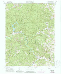
1961 Map of Mineral
USGS Topo · Published 1987About this map
Moonville and the nearby village of Mineral sit at the heart of this landscape, deeply shaped by the industrial extraction and transit of the mid-twentieth century. The winding course of Raccoon Creek and its many tributaries, such as Sandy Run and Hewitt Fork, dictate the placement of the Baltimore and Ohio railroad line, which threads through the valleys of the Zaleski State Forest.
Find a feature on this map
42 named features on this map. Tap any name to fly to it.
Don’t see what you’re looking for? This feature index may not catch every label — zoom into the map to look around manually.
Map Details
Editions of this 1961 Mineral Map
4 editions found
Other maps of this area

1903 · Athens
USGS Topo · 1:62,500

1904 · Zaleski
USGS Topo · 1:62,500

1905 · Athens
USGS Topo · 1:62,500

1905 · Wilkesville
USGS Topo · 1:62,500

1907 · Pomeroy
USGS Topo · 1:62,500

1907 · Zaleski
USGS Topo · 1:62,500

1908 · Wilkesville
USGS Topo · 1:62,500

1947 · Columbus
USGS Topo · 1:250,000

1960 · Albany
USGS Topo · 1:24,000

1961 · Columbus
USGS Topo · 1:250,000