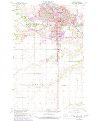
1966 Map of Minot
USGS Topo · Published 1980About this map
The Souris River carves a serpentine path through Minot, serving as the central geographic feature of this 1966 survey. The city's mid-century footprint is defined by a dense concentration of medical and educational institutions, including the campus of Minot State College and several prominent medical centers like John Moses Memorial Hospital, Trinity Hospital, and St Josephs Hospital. The map reveals the expansion of residential and commercial zones, with numerous schools such as Bishop Ryan High Sch and Sunnyside Sch serving established neighborhoods. Beyond the urban core, the landscape transitions into the agricultural and drainage patterns of the northern plains, marked by landmarks such as the Agriculture Experimental Station and the various coulees—including First Larson Coulee and Second Larson Coulee—which drain the surrounding townships of Harrison, Nedrose, Afton, and Sundre.
Find a feature on this map
46 named features on this map. Tap any name to fly to it.
Don’t see what you’re looking for? This feature index may not catch every label — zoom into the map to look around manually.
Map Details
Editions of this 1966 Minot Map
2 editions found
Other maps of this area

1928 · Minot
USGS Topo · 1:62,500

1929 · Sawyer
USGS Topo · 1:62,500

1948 · Burlington
USGS Topo · 1:24,000

1948 · Burlington
USGS Topo · 1:62,500

1948 · Minot NW
USGS Topo · 1:24,000

1948 · Surrey
USGS Topo · 1:24,000

1949 · Minot NW
USGS Topo · 1:24,000

1949 · Deering SW
USGS Topo · 1:24,000

1949 · Burlington SE
USGS Topo · 1:24,000

1949 · Surrey
USGS Topo · 1:24,000